If you have ever gone into the nursery and picked a plant or tree, later to realize it was not suitable to be planted in the environment in which you live, this can be avoided. Besides the scientific plant name and care instructions, you will notice the hardiness zone printed on its tag.
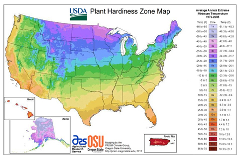
The USDA Hardiness Zone Map splits North America up into 11 separate planting zones. Each individual planting zone is around 10°F colder (or warmer) than the adjacent zone during an average winter. If you’re reading a plant description in a gardening magazine and you see a mention of a hardiness zone, then it’s likely referring to the USDA Hardiness Zone map.
A hardiness zone is based on average annual extreme minimum temperatures across a 30-year period. It’s not based on the lowest recorded temperature in a region or what might possibly happen in the future. Gardeners must keep this in mind as they choose plants and trees, especially if they are planning to “push” the hardiness zone they live in by planting trees and plants not suited for that particular hardiness zone. Something else to keep in mind is that there could be microclimates that won’t show up on a map – even one as detailed as the current USDA PHZM map.
Eastern Zones – The USDA map is great at its job of outlining the different gardening climates of the eastern half of North America. This is a comparatively flat area, which means it can be mapped out by drawing lines approximately parallel to the Gulf Coast around every 120 miles as you progress north. The lines will start to tilt northeast as the Eastern Seaboard approaches. The USDA map also accounts for the special climates caused by the Appalachian mountains and the Great Lakes.
Western Zones – A range of factors including winter lows, elevation and precipitation determine the growing climates in western North America. The weather in the west floats in from the Pacific Ocean, becoming less humid as it moves around the mountain ranges to the west. The growing climates in the west can vary quite a bit compared to the east, where cities in similar zones can grow the same plants in the same climates. The weather – and the plants that can be grown in it – in coastal Seattle are much different than what you can expect in the higher and more inland Tucson, Arizona. This is in spite of both cities being a part of zone 8 of the USDA map.
To find the zone for where you live, see http://planthardiness.ars.usda.gov/PHZMWeb/
Many of our customer’s aim to improve their well-manicured yards with trees, shrubs, and flowers. Of course the right sunlight, soil, and moisture conditions are factors needed for these plants to flourish. After being asked for specific species, we created a short list of popular trees and common shrubs that will thrive in Alpharetta and Roswell Ga. 7a and 7b are the zones for North Georgia, so next time you visit the nursery, be sure to look for plants that are conducive to living in these zones.
There are other environmental factors that determine whether a plant succeeds or fails on top of the hardiness zones. Wind levels, soil type and moisture, humidity, pollution, winter sunshine, and snow are all major contributing factors to plant survival. Whether or not a plant survives can also depend on where it is planted, how it is planted, their size, and their overall health.
The map was most recently updated in 2012 when the USDA adjusted the plant hardiness map to account for the warmer global temperatures occurring over the past thirty years. Refer to this resource when purchasing trees and plants for your garden and landscape.
Interactive Map: http://planthardiness.ars.usda.gov/phzmweb/interactivemap.aspx